| at: |
Paulding Forest |
Data from David Muse
 show on map
 animate
Trail users:

Elevation Profile
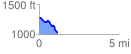
 1.162818 mi
 65.38 ft
 298.95 ft
 -233.57 ft
 4.87 %
GPX Downloads: Track Route
![]()
| at: |
Paulding Forest |
show on map
animate
1.162818 mi
65.38 ft
298.95 ft
-233.57 ft
4.87 %