| at: |
Chestatee WMA |
Data from David Muse
 show on map
 animate
Trail users:

Elevation Profile
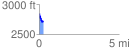
 0.257555 mi
 16.55 ft
 139.65 ft
 -123.10 ft
 10.27 %
GPX Downloads: Track Route
![]()
| at: |
Chestatee WMA |
show on map
animate
0.257555 mi
16.55 ft
139.65 ft
-123.10 ft
10.27 %