| at: |
Blue Ridge WMA |
Data from David Muse
 show on map
 animate
Trail users:

Elevation Profile
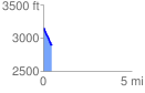
 0.479249 mi
 1.40 ft
 272.18 ft
 -270.78 ft
 10.76 %
GPX Downloads: Track Route
![]()
| at: |
Blue Ridge WMA |
show on map
animate
0.479249 mi
1.40 ft
272.18 ft
-270.78 ft
10.76 %