|
| at: |
Blue Ridge WMA |
Data from David Muse
 show on map
 animate
Trail users:


Elevation Profile
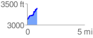
 0.889992 mi
 291.15 ft
 17.97 ft
 273.17 ft
 6.20 %
GPX Downloads: Track Route
![]()
|
| at: |
Blue Ridge WMA |
show on map
animate
0.889992 mi
291.15 ft
17.97 ft
273.17 ft
6.20 %