| at: |
Blue Ridge WMA Amicalola/Nimblewill/Tickanetley |
Data from David Muse
 show on map
 animate


Trail users:

Elevation Profile
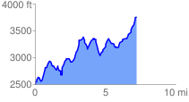
 7.341902 mi
 2767.91 ft
 1500.03 ft
 1267.87 ft
 7.14 %
GPX Downloads: Track Route
![]()
| at: |
Blue Ridge WMA Amicalola/Nimblewill/Tickanetley |
show on map
animate
7.341902 mi
2767.91 ft
1500.03 ft
1267.87 ft
7.14 %