| at: |
Olde Rope Mill Park |
Data from David Muse
 show on map
 animate
Trail users:


Elevation Profile
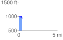
 0.430447 mi
 51.99 ft
 86.37 ft
 -34.38 ft
 3.80 %
GPX Downloads: Track Route
![]()
| at: |
Olde Rope Mill Park |
show on map
animate
0.430447 mi
51.99 ft
86.37 ft
-34.38 ft
3.80 %