|
| at: |
Gaddistown/Canada Creek |
Data from David Muse
 show on map
 animate
Trail users:


Elevation Profile
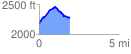
 1.913841 mi
 352.80 ft
 246.36 ft
 106.43 ft
 3.49 %
GPX Downloads: Track Route
![]()
|
| at: |
Gaddistown/Canada Creek |
show on map
animate
1.913841 mi
352.80 ft
246.36 ft
106.43 ft
3.49 %