| at: |
Paulding Forest |
Data from David Muse
 show on map
 animate
Trail users:


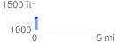
Elevation Profile
 0.235834 mi
 32.83 ft
 0.10 ft
 32.73 ft
 2.64 %
GPX Downloads: Track Route
![]()
| at: |
Paulding Forest |
show on map
animate
0.235834 mi
32.83 ft
0.10 ft
32.73 ft
2.64 %