| at: |
Paulding Forest |
Data from Georgia DOT
 show on map
 animate
Trail users:


Elevation Profile
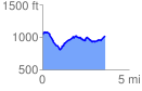
 3.633012 mi
 436.11 ft
 453.28 ft
 -17.18 ft
 2.36 %
GPX Downloads: Track Route
![]()
| at: |
Paulding Forest |
show on map
animate
3.633012 mi
436.11 ft
453.28 ft
-17.18 ft
2.36 %