| at: |
Paulding Forest |
Data from Georgia DOT
 show on map
 animate
Trail users:


Elevation Profile
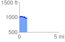
 0.988807 mi
 58.35 ft
 85.01 ft
 -26.66 ft
 1.63 %
GPX Downloads: Track Route
![]()
| at: |
Paulding Forest |
show on map
animate
0.988807 mi
58.35 ft
85.01 ft
-26.66 ft
1.63 %