| at: |
Paulding Forest |
Data from Georgia DOT
 show on map
 animate
Trail users:


Elevation Profile
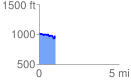
 1.007936 mi
 90.73 ft
 132.21 ft
 -41.48 ft
 2.48 %
GPX Downloads: Track Route
![]()
| at: |
Paulding Forest |
show on map
animate
1.007936 mi
90.73 ft
132.21 ft
-41.48 ft
2.48 %