| at: |
Paulding Forest |
Data from Georgia DOT
 show on map
 animate
Trail users:


Elevation Profile
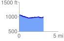
 3.118600 mi
 185.35 ft
 262.55 ft
 -77.20 ft
 1.59 %
GPX Downloads: Track Route
![]()
| at: |
Paulding Forest |
show on map
animate
3.118600 mi
185.35 ft
262.55 ft
-77.20 ft
1.59 %