| at: |
Bremen and Carrollton Area Roads |
Data from Georgia DOT
 show on map
 animate
Trail users:


Elevation Profile
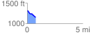
 0.796715 mi
 6.08 ft
 158.95 ft
 -152.88 ft
 3.78 %
GPX Downloads: Track Route
![]()
| at: |
Bremen and Carrollton Area Roads |
show on map
animate
0.796715 mi
6.08 ft
158.95 ft
-152.88 ft
3.78 %