|
| at: |
Amicalola/Nimblewill/Tickanetley |
Data from David Muse
 show on map
 animate
Trail users:


Elevation Profile
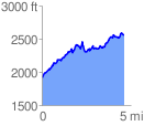
 4.670330 mi
 1530.73 ft
 891.27 ft
 639.46 ft
 6.21 %
GPX Downloads: Track Route
![]()
|
| at: |
Amicalola/Nimblewill/Tickanetley |
show on map
animate
4.670330 mi
1530.73 ft
891.27 ft
639.46 ft
6.21 %