| at: |
Bremen and Carrollton Area Roads |
Data from Georgia DOT
 show on map
 animate
Trail users:


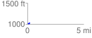
Elevation Profile
 0.209256 mi
 26.16 ft
 32.10 ft
 -5.94 ft
 2.91 %
GPX Downloads: Track Route
![]()
| at: |
Bremen and Carrollton Area Roads |
show on map
animate
0.209256 mi
26.16 ft
32.10 ft
-5.94 ft
2.91 %