| at: |
Bremen and Carrollton Area Roads |
Data from Georgia DOT
 show on map
 animate
Trail users:


Elevation Profile
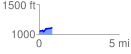
 0.816898 mi
 109.56 ft
 27.49 ft
 82.07 ft
 2.54 %
GPX Downloads: Track Route
![]()
| at: |
Bremen and Carrollton Area Roads |
show on map
animate
0.816898 mi
109.56 ft
27.49 ft
82.07 ft
2.54 %