|
| at: |
Tombigbee National Forest - South |
Data from USFS GIS
 show on map
 animate
Trail users:


Elevation Profile
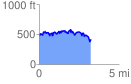
 3.261773 mi
 727.93 ft
 770.89 ft
 -42.96 ft
 4.48 %
GPX Downloads: Track Route
![]()
|
| at: |
Tombigbee National Forest - South |
show on map
animate
3.261773 mi
727.93 ft
770.89 ft
-42.96 ft
4.48 %