| at: |
Tombigbee National Forest - South |
Data from USFS GIS
 show on map
 animate
Trail users:


Elevation Profile
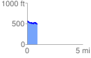
 0.917973 mi
 111.29 ft
 177.83 ft
 -66.54 ft
 3.67 %
GPX Downloads: Track Route
![]()
| at: |
Tombigbee National Forest - South |
show on map
animate
0.917973 mi
111.29 ft
177.83 ft
-66.54 ft
3.67 %