| at: |
Tombigbee National Forest - South |
Data from USFS GIS
 show on map
 animate
Trail users:


Elevation Profile
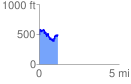
 1.170707 mi
 422.22 ft
 398.97 ft
 23.26 ft
 6.83 %
GPX Downloads: Track Route
![]()
| at: |
Tombigbee National Forest - South |
show on map
animate
1.170707 mi
422.22 ft
398.97 ft
23.26 ft
6.83 %