| at: |
Tombigbee National Forest - South |
Data from USFS GIS
 show on map
 animate
Trail users:


Elevation Profile
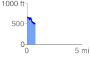
 0.765121 mi
 119.75 ft
 311.30 ft
 -191.56 ft
 7.71 %
GPX Downloads: Track Route
![]()
| at: |
Tombigbee National Forest - South |
show on map
animate
0.765121 mi
119.75 ft
311.30 ft
-191.56 ft
7.71 %