| at: |
Tombigbee National Forest - North |
Data from USFS GIS
 show on map
 animate
Trail users:


Elevation Profile
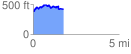
 1.772150 mi
 295.55 ft
 254.57 ft
 40.99 ft
 3.16 %
GPX Downloads: Track Route
![]()
| at: |
Tombigbee National Forest - North |
show on map
animate
1.772150 mi
295.55 ft
254.57 ft
40.99 ft
3.16 %