| at: |
Tombigbee National Forest - North |
Data from USFS GIS
 show on map
 animate
Trail users:


Elevation Profile
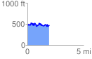
 1.957789 mi
 397.69 ft
 407.72 ft
 -10.03 ft
 3.94 %
GPX Downloads: Track Route
![]()
| at: |
Tombigbee National Forest - North |
show on map
animate
1.957789 mi
397.69 ft
407.72 ft
-10.03 ft
3.94 %