| at: |
Tombigbee National Forest - North |
Data from USFS GIS
 show on map
 animate
Trail users:

Elevation Profile
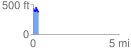
 0.328062 mi
 70.36 ft
 138.37 ft
 -68.01 ft
 7.99 %
GPX Downloads: Track Route
![]()
| at: |
Tombigbee National Forest - North |
show on map
animate
0.328062 mi
70.36 ft
138.37 ft
-68.01 ft
7.99 %