| at: |
Tombigbee National Forest - North |
Data from USFS GIS
 show on map
 animate
Trail users:


Elevation Profile
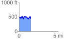
 1.540541 mi
 455.69 ft
 461.24 ft
 -5.54 ft
 5.67 %
GPX Downloads: Track Route
![]()
| at: |
Tombigbee National Forest - North |
show on map
animate
1.540541 mi
455.69 ft
461.24 ft
-5.54 ft
5.67 %