| at: |
Tombigbee National Forest - North |
Data from USFS GIS
 show on map
 animate
Trail users:


Elevation Profile
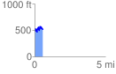
 0.584761 mi
 199.89 ft
 230.02 ft
 -30.13 ft
 7.45 %
GPX Downloads: Track Route
![]()
| at: |
Tombigbee National Forest - North |
show on map
animate
0.584761 mi
199.89 ft
230.02 ft
-30.13 ft
7.45 %