| at: |
Holly Springs National Forest - South |
Data from USFS GIS
 show on map
 animate
Trail users:


Elevation Profile
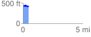
 0.461376 mi
 63.92 ft
 90.47 ft
 -26.55 ft
 3.71 %
GPX Downloads: Track Route
![]()
| at: |
Holly Springs National Forest - South |
show on map
animate
0.461376 mi
63.92 ft
90.47 ft
-26.55 ft
3.71 %