| at: |
Holly Springs National Forest - South |
Data from USFS GIS
 show on map
 animate
Trail users:


Elevation Profile
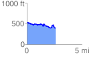
 2.650664 mi
 269.93 ft
 402.05 ft
 -132.11 ft
 2.87 %
GPX Downloads: Track Route
![]()
| at: |
Holly Springs National Forest - South |
show on map
animate
2.650664 mi
269.93 ft
402.05 ft
-132.11 ft
2.87 %