|
| at: |
Holly Springs National Forest - North |
Data from USFS GIS
 show on map
 animate
Trail users:


Elevation Profile
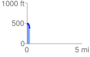
 0.275004 mi
 31.88 ft
 137.37 ft
 -105.49 ft
 9.46 %
GPX Downloads: Track Route
![]()
|
| at: |
Holly Springs National Forest - North |
show on map
animate
0.275004 mi
31.88 ft
137.37 ft
-105.49 ft
9.46 %