|
| at: |
Holly Springs National Forest - North |
Data from USFS GIS
 show on map
 animate
Trail users:


Elevation Profile
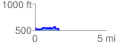
 1.697044 mi
 190.07 ft
 207.48 ft
 -17.41 ft
 2.32 %
GPX Downloads: Track Route
![]()
|
| at: |
Holly Springs National Forest - North |
show on map
animate
1.697044 mi
190.07 ft
207.48 ft
-17.41 ft
2.32 %