| at: |
Holly Springs National Forest - North |
Data from USFS GIS
 show on map
 animate
Trail users:


Elevation Profile
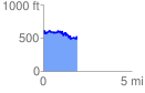
 1.959118 mi
 311.61 ft
 421.29 ft
 -109.68 ft
 4.07 %
GPX Downloads: Track Route
![]()
| at: |
Holly Springs National Forest - North |
show on map
animate
1.959118 mi
311.61 ft
421.29 ft
-109.68 ft
4.07 %