|
| at: |
Holly Springs National Forest - North |
Data from USFS GIS
 show on map
 animate
Trail users:


Elevation Profile
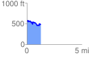
 1.260198 mi
 176.97 ft
 257.34 ft
 -80.38 ft
 3.87 %
GPX Downloads: Track Route
![]()
|
| at: |
Holly Springs National Forest - North |
show on map
animate
1.260198 mi
176.97 ft
257.34 ft
-80.38 ft
3.87 %