| at: |
Holly Springs National Forest - North |
Data from USFS GIS
 show on map
 animate
Trail users:


Elevation Profile
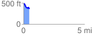
 0.471614 mi
 53.23 ft
 155.81 ft
 -102.59 ft
 6.26 %
GPX Downloads: Track Route
![]()
| at: |
Holly Springs National Forest - North |
show on map
animate
0.471614 mi
53.23 ft
155.81 ft
-102.59 ft
6.26 %