|
| at: |
Holly Springs National Forest - North |
Data from USFS GIS
 show on map
 animate
Trail users:


Elevation Profile
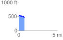
 0.720098 mi
 79.82 ft
 153.62 ft
 -73.80 ft
 4.04 %
GPX Downloads: Track Route
![]()
|
| at: |
Holly Springs National Forest - North |
show on map
animate
0.720098 mi
79.82 ft
153.62 ft
-73.80 ft
4.04 %