| at: |
Holly Springs National Forest - North |
Data from USFS GIS
 show on map
 animate
Trail users:


Elevation Profile
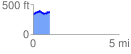
 0.976114 mi
 169.76 ft
 117.67 ft
 52.10 ft
 3.29 %
GPX Downloads: Track Route
![]()
| at: |
Holly Springs National Forest - North |
show on map
animate
0.976114 mi
169.76 ft
117.67 ft
52.10 ft
3.29 %