|
| at: |
Holly Springs National Forest - North |
Data from USFS GIS
 show on map
 animate
Trail users:


Elevation Profile
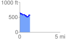
 1.330304 mi
 199.51 ft
 320.08 ft
 -120.58 ft
 4.56 %
GPX Downloads: Track Route
![]()
|
| at: |
Holly Springs National Forest - North |
show on map
animate
1.330304 mi
199.51 ft
320.08 ft
-120.58 ft
4.56 %