| at: |
Holly Springs National Forest - North |
Data from USFS GIS
 show on map
 animate
Trail users:


Elevation Profile
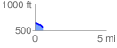
 0.591639 mi
 24.09 ft
 89.56 ft
 -65.48 ft
 2.87 %
GPX Downloads: Track Route
![]()
| at: |
Holly Springs National Forest - North |
show on map
animate
0.591639 mi
24.09 ft
89.56 ft
-65.48 ft
2.87 %