| at: |
Holly Springs National Forest - North |
Data from USFS GIS
 show on map
 animate
Trail users:


Elevation Profile
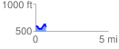
 0.717806 mi
 136.37 ft
 119.33 ft
 17.05 ft
 3.60 %
GPX Downloads: Track Route
![]()
| at: |
Holly Springs National Forest - North |
show on map
animate
0.717806 mi
136.37 ft
119.33 ft
17.05 ft
3.60 %