|
| at: |
Holly Springs National Forest - North |
Data from USFS GIS
 show on map
 animate
Trail users:


Elevation Profile
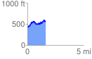
 1.655631 mi
 440.76 ft
 283.17 ft
 157.60 ft
 5.04 %
GPX Downloads: Track Route
![]()
|
| at: |
Holly Springs National Forest - North |
show on map
animate
1.655631 mi
440.76 ft
283.17 ft
157.60 ft
5.04 %