| at: |
Holly Springs National Forest - North |
Data from USFS GIS
 show on map
 animate
Trail users:


Elevation Profile
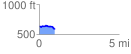
 0.987379 mi
 46.62 ft
 102.87 ft
 -56.25 ft
 1.97 %
GPX Downloads: Track Route
![]()
| at: |
Holly Springs National Forest - North |
show on map
animate
0.987379 mi
46.62 ft
102.87 ft
-56.25 ft
1.97 %