| at: |
Holly Springs National Forest - North |
Data from USFS GIS
 show on map
 animate
Trail users:


Elevation Profile
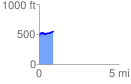
 0.877512 mi
 151.87 ft
 70.55 ft
 81.32 ft
 3.28 %
GPX Downloads: Track Route
![]()
| at: |
Holly Springs National Forest - North |
show on map
animate
0.877512 mi
151.87 ft
70.55 ft
81.32 ft
3.28 %