|
| at: |
Delta National Forest |
Data from USFS GIS
 show on map
 animate
Trail users:


Elevation Profile
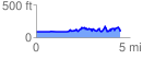
 4.502980 mi
 516.36 ft
 513.71 ft
 2.65 ft
 2.17 %
GPX Downloads: Track Route
![]()
|
| at: |
Delta National Forest |
show on map
animate
4.502980 mi
516.36 ft
513.71 ft
2.65 ft
2.17 %