|
| at: |
Bienville National Forest |
Data from USFS GIS
 show on map
 animate
Trail users:


Elevation Profile
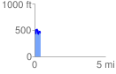
 0.423670 mi
 150.14 ft
 183.79 ft
 -33.65 ft
 8.22 %
GPX Downloads: Track Route
![]()
|
| at: |
Bienville National Forest |
show on map
animate
0.423670 mi
150.14 ft
183.79 ft
-33.65 ft
8.22 %