|
| at: |
Bienville National Forest |
Data from USFS GIS
 show on map
 animate
Trail users:


Elevation Profile
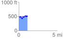
 1.143851 mi
 194.92 ft
 203.29 ft
 -8.36 ft
 3.37 %
GPX Downloads: Track Route
![]()
|
| at: |
Bienville National Forest |
show on map
animate
1.143851 mi
194.92 ft
203.29 ft
-8.36 ft
3.37 %