|
| at: |
Bienville National Forest |
Data from USFS GIS
 show on map
 animate
Trail users:


Elevation Profile
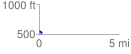
 0.182144 mi
 9.53 ft
 41.23 ft
 -31.70 ft
 4.29 %
GPX Downloads: Track Route
![]()
|
| at: |
Bienville National Forest |
show on map
animate
0.182144 mi
9.53 ft
41.23 ft
-31.70 ft
4.29 %