|
| at: |
Bienville National Forest |
Data from USFS GIS
 show on map
 animate
Trail users:


Elevation Profile
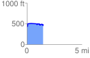
 1.484064 mi
 148.38 ft
 168.33 ft
 -19.95 ft
 2.15 %
GPX Downloads: Track Route
![]()
|
| at: |
Bienville National Forest |
show on map
animate
1.484064 mi
148.38 ft
168.33 ft
-19.95 ft
2.15 %