| at: |
Bienville National Forest |
Data from USFS GIS
 show on map
 animate
Trail users:


Elevation Profile
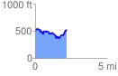
 2.193169 mi
 360.25 ft
 354.06 ft
 6.19 ft
 3.11 %
GPX Downloads: Track Route
![]()
| at: |
Bienville National Forest |
show on map
animate
2.193169 mi
360.25 ft
354.06 ft
6.19 ft
3.11 %