|
| at: |
Bienville National Forest |
Data from USFS GIS
 show on map
 animate
Trail users:


Elevation Profile
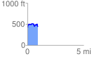
 0.905707 mi
 159.03 ft
 143.44 ft
 15.59 ft
 3.33 %
GPX Downloads: Track Route
![]()
|
| at: |
Bienville National Forest |
show on map
animate
0.905707 mi
159.03 ft
143.44 ft
15.59 ft
3.33 %