|
| at: |
Bienville National Forest |
Data from USFS GIS
 show on map
 animate
Trail users:


Elevation Profile
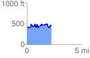
 2.221678 mi
 443.04 ft
 379.26 ft
 63.78 ft
 3.78 %
GPX Downloads: Track Route
![]()
|
| at: |
Bienville National Forest |
show on map
animate
2.221678 mi
443.04 ft
379.26 ft
63.78 ft
3.78 %