| at: |
Bienville National Forest |
Data from USFS GIS
 show on map
 animate
Trail users:


Elevation Profile
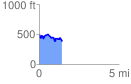
 1.422396 mi
 194.61 ft
 290.21 ft
 -95.60 ft
 3.86 %
GPX Downloads: Track Route
![]()
| at: |
Bienville National Forest |
show on map
animate
1.422396 mi
194.61 ft
290.21 ft
-95.60 ft
3.86 %