|
| at: |
Bienville National Forest |
Data from USFS GIS
 show on map
 animate
Trail users:


Elevation Profile
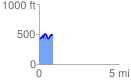
 0.849842 mi
 198.72 ft
 139.99 ft
 58.74 ft
 4.43 %
GPX Downloads: Track Route
![]()
|
| at: |
Bienville National Forest |
show on map
animate
0.849842 mi
198.72 ft
139.99 ft
58.74 ft
4.43 %